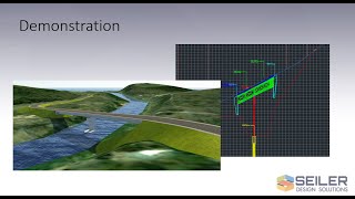
In this video, Seiler Design Solutions will show you how to export Civil 3D objects to a Google Earth .KMZ or .KML file and view them in Google Earth. This is applicable to civil engineers, planners, surveyors and designers fo visualizing Civil 3D drawings in Google Earth for sharing with others, visualization or other planning purposes.

If you have any additional questions related to this video, please contact us.

Unable to view 3rd party video sources like YouTube? Please watch using this alternative source.


You may also like

Modifying Civil 3D Pipe Labels with Expressions
9:00
Seiler Design Solutions presents how to use expressions to modify a ...
Pipe Network Objects using the Autodesk Connector for ArcGIS in Civil 3D 2020.1
In this video, Seiler Design Solutions presents the third in a series ...
Shared Reference Point Add-In for Autodesk Civil 3D and Revit
10:12
In this video, I demonstrate the Shared Reference Coordinate Extension ...
Upload Civil Objects to ArcGIS Online with the Autodesk Connector in Civil 3D
Seiler Design Solutions presents the fourth in a series of videos ...
Page 2 of 2